Chusok is the Korean Thanksgiving. As it is a lunar holiday, the 3-day vacation associated with it may fall at any time during the week. This year, Chusok fell on Tuesday, so we got a 5-day weekend. Instead of being stuck on a crowded bus or train, or left to wander around an empty city, I headed back out to Ganghwa Island. It is technically part of Incheon, but is about 40 km northwest of what most people consider Incheon.
Day 1: The trip out
 I headed out on Saturday, aiming for Donmak beach, located on the south end of the island, as my first camping spot. After crossing over the Choji bridge, I headed south along the coast. I've been along the east coast between the bridge, but this was the first time I had explored this area. The east cost is mainly old forts and battlements from the 19th century. Once I got away from the coast, the island revealed itself to hold a more than just historical artifacts. Typical Korean construction consists of concrete boxes. Lots of concrete boxes. But on Ganghwa, there exhibits the existence of actual architects in Korea. I found the architecture to be quite varied and a welcome surprise. Here are a couple of the more interesting buildings I found. The green and yellow one is a cafe. I think the pink and white one is a residence, but I'm not sure.
 As I was getting closer to the beach, I was worried that it wouldn't be very habited. So I was making mental notes about the last stores and restaurants that I saw. When I got to over the final hill, those concerns were quickly alleviated. The entire stretch of road across from the beach was lined with restaurants and hotels. The only thing missing was water. The tide was low and with Ganghwa's gently sloping shore, the water was nowhere to be seen. So I headed down to the beach area to find a camping spot. After seeing a price list, I went to pay a woman who seemed to be collecting money. She brushed me off and seemed to indicate that someone would be around later to collect my money. She also seemed to tell me that I couldn't actually camp on the beach. So instead, I was left to set up on the terrace above the beach. Which was covered with rocks. They were smooth rocks, but rocks nonetheless. Given the wide array of services nearby, I decided to stay for the night anyways. There was an interesting set of performances that night by various high school groups. But there was also a constant stream of people hanging out on the beach all night long. I believe the last group finally dispersed around 5:30 am. So between the rocks and the people, it isn't a very good place to get a good nights sleep.
Distance: 46 km
Day 2: Climbing Mountains  After my restless night of sleep, I headed out Sunday morning to climb a nearby mountain. Mani-san is the tallest mountain on Ganghwa, and one of the most popular destinations. Biking around the mountain, I easily found the "base camp." A little town at the base of the mountain a flutter with activity. Lots of cars and lots of people milling around. Staying on the trail was quite easy, as it was well marked and there was a steady flow of people to follow. The view from the mountain is well worth the hike up. You can see the surrounding landscape and nearby islands. And you can actually make out parts of Incheon through the smog.
 The big draw of Mani-san is actually Chamseongdan, an old altar on a site that has been reportedly used for 4,000 years. The site is considered one of the most sacred in Korea, and holds a great deal of historical significance.
 At the top of Mani-san, a crowd gathers to rest, eat, drink, and take pictures. There's even an ice-cream saleswoman up there. If you notice, there's a helipad there as well. I'm not sure what the story behind it is. I did hear a helicopter in that direction as I was hiking down, but I didn't see if it was actually landing. Maybe it's used to refill the ice cream supply.
 After hiking down Mani-san, I headed west to the ferry terminal. After a short ride on the ferry, I was on Seokmo-do. There's one mountain on the island, and one road that goes around the mountain. So it's easy to figure out where you are going. The destination on this island is Bomun-sa, a Buddhist temple. Finding the spot isn't hard, as there is again a busy area with shops and restaurants where all the Korean tourists gather. The temple itself is pretty interesting, but the highlight is the Buddha carved on the side of the mountain.
After returning to Ganghwa-do, I decided to head towards a campsite near Ganghwa-eup (the main town on Ganghwa). Since the sun was about to go down, I decided it would be better to take a less busy side road. On the map, it looked pretty straightforward, as this secondary road ran parallel to the main route, and merged at about the exact spot I was headed for. Unfortunately, trying to maintain the road proved a little more difficult than I thought. So in the dark of the evening, I ran into a dead end, and still hadn't reached my destination. I tried getting directions from a couple of Koreans that I saw, but they did want anything to do with the foreigner. So as I was back tracking, I noticed a bank of light towers lit up. Looking closer, I realized they were lighting a tennis court. And people were playing tennis. Figuring that I might find someone who would help me, I headed to the tennis court. While no one there spoke much English, they were quite helpful in pointing me in the correct direction.
So after getting directions, I headed back to the main route. Fortunately there wasn't much traffic, and nobody ran over me in the dark. As I got closer to town, I kept an eye out for the campsite but failed to spot any signs. Given the darkness around me, and the sprinkling of rain falling, I decided to continue heading into town. Since I'd been there before, I had a general idea of where to find a hotel. After a bit of pedaling around, I was able to find a nice little Yeogwan, which is a type of Korean hotel. There, I settled into a pizza and War of the Worlds, dubbed into Korean.
Distance: 52 km
Day 3: Meeting the Marines Monday's goal was to tour the northern end of the island. There were a couple of dolmen sights marked on the map, and numerous battlefield remains line the coast. It's also just south of North Korea. My first stop was to see the Ganghwa dolmen. They actually have quite a few dolmens on the island, but this seems to be the best preserved and most popular dolmen to visit. There's a small park around the dolmen with models of other dolmens from around Korea.
After seeing these dolmens, I wanted to visit another dolmen site on the island. As I was getting close to the Gyosan-ri Dolmens, I stopped to check my map. Somebody stopped their car and pointed me in the right direction. He also told me that there would be a checkpoint, and to tell them that I was not going fishing. Since I didn't have a fishing pole, I figured that wouldn't be too hard to pull of. So I found the checkpoint, they asked if I was going fishing, and I quickly told them no. So they let me pass. From there, I headed up to the dolmens. These other dolmens aren't nearly as impressive as the Ganghwa dolmen. Although trying to actually find them in the woods is like going on an archeology exhibition.
After visiting the dolmen sight, I decided to take a little tour around the north coast and check out the DMZ area. So after an hour or so of roaming around, taking pictures, and getting water from the locals, I saw a bunker. Not unlike the one I saw up by Aegibong. So I decided to take a look around. After getting some pictures of the bunker, the South Korean fence, and North Korea, I headed back to my bike. Just as done packing my things back up and ready to head out, I saw a Marine truck go by. I could hear it come to a stop, and back up towards me. They pulled up next to me and the guy asked if I had taken any pictures. Thinking that it wouldn't be a good idea to lie to him, I told him yes.  So he had to call his commander and report me. He then went through my pictures and deleted everything from the area. Pictures of the bunker, the fence, North Korea, and even pictures of the rice fields weren't acceptable. After that, they let me continue, warning me that I shouldn't be taking pictures. But not to worry, they missed this photo from when I was checking out the dolmens. Behold, the forbidden look at Ganghwa's northern rice fields, the Han River, and North Korea. Not very exciting. And a lot less informative than Google Earth.
 Continuing on my sojourn through the forbidden zone, I eventually reached another checkpoint. As I was about to cruise past them, one of the Marines told me stop. He told me it was a restricted area and I shouldn't be there. So they called up their commander, undoubtedly the same guy the last Marine called, to tell him that there was a foreigner riding around the forbidden zone on his bike. Of course the commander already knew about me, so they waved me through. A short while later, I came across an interesting cemetery. Built on the side of a hill, each plot has a small hill built on it. Much like the historic burial mounds that are scattered around Korea, but on a much smaller scale. Since I'd already been through the checkpoint to get out of the restricted zone, I decided to take some pictures. Pictures of the cemetery and of North Korea, which could be seen across the river. Soon after leaving the cemetery, I passed another checkpoint. So I'm assuming these pictures weren't suppose to be taken either. But here they are.
A look at North Korea. Not much different then the view from Aegibong, so I'm not sure what the big to do was all about. 
After passing through the final checkpoint, I headed down the east coast towards a campground I was planning to stay at. Since I hadn't had a chance to eat much, I ended up stopping at the little Eel Town along the coast. It's a collection of several restaurants that specialize in eel. While I've had eel sushi, I've never had an entire meal of eel before. The meal was rather expensive, at 30,000 won, or over $30, but it was very good. The eel was filleted and sliced up, then grilled at my table. There were also 20 side dished. And if you know anything about Korean food, it's all about the number of side dishes. A cheap-o kimbab place will give you two - pickled radish and kimchi. And low range neighborhood joint will offer between five and ten side dishes. But to actually get 20 side dishes is the mark of a quality dining establishment.
After my big dinner, I managed to drag myself to the camp site. As I was getting something to drink at the FamilyMart just outside the camp grounds, another foreigner showed up on his bike. We started talking and he turned out to have some pretty impressive credentials. He has spent much of the last 10 years biking around Asia, including his current trip, which is at just over 1.5 years long. He started in Turkey, biked to the Caspian, took the ferry to Turkmenistan, went through the stans, into China. After wintering in Thailand, he biked up from there and just recently took the ferry over from China. He was headed to Busan, the ferry to Japan, and is going to bike around Japan for several months. I spent a fair amount of time talking to him over the next couple of days, picking his brain for tips and pointers. I've considered biking from Korea across Asia, and he's definitely been an inspiration for my future endeavors. Back to the campsite. It's called Hamheodongcheon, and it's located on the eastern side of Mani-san, just by Jeongsu-sa. Campsites are terraced up the side of the mountain, with bathroom and shower facilities available. There's a small camping fee, W1,500, that seems to be sporadically collected in the non-camping season. I didn't go all the way the top of the grounds, but it seems that the higher you go, the nicer the campsites are. For anyone looking to camp out, I highly recommend this location. A FamilyMart is right there, the beach is a few kilometers away, as is the small town of Onsu.
Distance: 63 km
Day 4: Pedaling Around
My bike is a tad too small for me, so after several days of riding, especially up and down hills, my knees start to ache a bit. So on Tuesday, I decided to take it relatively easy and save my energy for the ride home. My first stop was Jeongdeung-sa, a Buddhist temple not too far from my campsite. It dates from the 17th century, and is one of the best remaining temples I've seen here. Many of Korea's temples were destroyed by the Japanese during their occupation.
Continuing east to the coast, the road became quite congested. Cars were backed up for a couple of kilometers on the way to the bridge crossing back to the mainland. There was a side path most of the way, which I believe, in theory, is for bicycles.  Instead, it was lined by tents where local farmers sold their grapes, and in turn, a car of people buying grapes. So biking along this path wasn't very feasible. Instead, I had to squeeze between the cars and the edge of the road. Once I got past the bridge, traffic cleared up quite a bit. When I stopped by a convenience store for some water and ice cream, I found this store. It looks more like a tourist trap in South Dakota than something from Korea.
Continuing along the south, I eventually made my way back to the beach. And this time, the water was there.
Distance: 45 km
Day 5: Returning home
My final day was just packing up my gear and heading home. The only difficulty was when I departed from the main road and ended up heading the wrong way - back to Ganghwa. After some tricky maneuvering through rice fields, and an odd industrial town out in the middle of nowhere, I was eventually able to get back on track and find a subway station. While numbered roads can be interesting and fun, it's not the way to travel quickly.
Distance: 51 km
Overall, I highly recommend Ganghwa. If you're driving, there are tons of minbaks (minbaks are like a Korean bed-and-breakfast), pensions (the equivalent of resort condos), and motels all over the island. There's also a great camping site as well. If you bike, it's not too far from Gyeyang Station, and the island is pretty easy to get around. It'll more than likely be a repeat destination for me in the coming months.
Wednesday, September 26, 2007
Ganghwa-do


Sunday, September 9, 2007
Return to Si Island
This weekend, I returned to Si-do and the Full House beach. My last visit is detailed here. I didn't visit the sculpture beach on Mo-do this time, nor Jangbong-do. But I did get to camp out on a beach completely free of anyone else. I think there was a caretaker staying in the house, but I only saw him once, when he was getting coffee from the machine. So there were no fireworks, no late night singing, no noise at all. It was quite nice.
I got a nice sunset, courtesy of China and its pollution. I'll have to remember to find a more westward facing beach the next time. 
Saw my first jellyfish up close and personal. 
At low tide, the gap between Si-do and Sin-do disappears and turns into a mud flat. In the old days, this was the only time people could cross back and forth between the islands. 
Saturday, June 16, 2007
Muui-do
The latest island I visited is Muui-do. It can be reached by a short ferry ride from Jamjin-do, which is accessible by bridge at the southwest corner of the airport island. It's a small island, about 6km long and 2-3km wide. There are a couple of nice beaches that look like they'll get pretty crowded. Crowds were already beginning to develop, and the Korean beach season doesn't begin until July. There is an admission fee to the beaches though - W2,000, or about $2 - and each beach requires a separate fee. Here is a picture of one of the beaches.
The ride to the island is quite easy. From Incheon station it's a short hop to Wolmi-do. Then take the ferry to the airport island. From the ferry, it is then a 20km very flat and straight ride to the next ferry. Another short ferry ride and you're back to biking. The island itself is fairly hilly, but given the size of the island, it's not too bad. But access to both beaches requires a steep climb and descent. It's an easy day trip, even by bicycle.
Monday, May 28, 2007
DeokJeok-do
 My latest weekend trip was to DeokJeok Island. It's a little further west (the pin in the bottom left corner), but it's still a manageable one hour away on the fast ferry. The slower car ferry, which we returned on, takes almost three hours. Unfortunately, Google Earth doesn't have a very clear picture of the island, so I'm just posting the larger overview.
  The island itself it pretty small. We biked around it on Saturday, and it was about 15 km. But it is the hilliest place I've been to yet. The ride from the ferry terminal to the beach involved several climbs, including one up to 80 meters. The trip around the rest of the island had several larger hills as well, with a top elevation of just over 150 meters (approx. 500 feet). But the beach itself was quite nice. Almost 2 km long, with lots of flat sand to camp on.
  In addition to my normal biking / traveling partner, we were joined by a large contingency of other westerners, who were making their semi-annual pilgrimage to the island. It was nice to have some company, and we had a veritable tent city going on. This is just one section of the camping area. We're finally starting to learn how to camp properly in Korea. This time I brought a portable stove. Next time, we'll have to remember to bring the hot dogs and condiments as these little islands don't have a lot of food to choose from.
A little bonus on the ferry ride was passing under the new bridge being constructed from Song-do to the airport island. We went right between the pylons that are going to hold up the section of the road that allows sea traffic into Incheon Harbor. It was a little hazy on the way back, so it's hard to see just how far the pylons stretch in both directions. 

Sunday, May 20, 2007
Bukdo-myeon
With beaches of shallower depth and, smooth slope shapes and, beautiful White sand, Buk do beaches provide, Safest and joyful stay for Family [sic] - Ongjin County tourist information

Map key:
Red line = Saturday bike route
Orange line = Sunday bike route
Blue line = Saturday ferry rides
Purple line = Sunday ferry rides
Saturday distance: approximately 60 km
Sunday distance: approximately 40 km
It was another nice weekend, so we decided to check out some more of the local islands. This time, we headed up to Bukdo-myeon, which is a set of four islands just north of the airport island. After meeting my friend at Incheon station, we made the short ride over to Wolmi-do. From there, ferries run every 20 minutes to the airport island. The ride down the south coast of the airport island is nice and flat, with lots of room on the shoulder. Although there was a strong head wind pushing against us. On the southwest coast, there is a small bridge that connects to a small island and from there you can take a ferry to Mui-do. But that is another trip. We headed back to the main road and wound through the hills north. Turning west, we once again were on flat, man made land, this time with the wind at our backs. About halfway back across the island there is the next ferry departure point, Mokko.
From Mokko, there are hourly ferries to Sin-do. When we arrived in Sin-do, the people seemed very friendly. One guy greeted us in English and asked if we were looking for some hiking trails. The little old lady selling potatoes and corn on the top of the boat ramp asked us a few questions in Korean. Although answering where I'm from is about the extent of my linguistic abilities. Sin-do is a pretty small island that took us about half an hour to bike around. Sin-do is then connected to Si-do by bridge. It too is a small island that just took us about 10 minutes to cross. Finally, the third island of Mo-do is also connected by bridge.
 On Mo-do, there is one of the more interesting attractions I've seen in Korea. There is a surrealistic sculpture garden on the beach. A lot of the works were inspired by Dali and other artists, but it is quite an unusual site here in Korea. Along with the sculpture garden, there is a nice looking pension you can spend the night it, a cafe, and an old fishing vessel on the beach.
This sculpture, for example, was obviously based on a Magritte painting.

 From there, we backed tracked to Si-do and started looking for a beach to camp out at. We found a nice, and for the most part unoccupied, beach on the north side of the island. There was one neighbor - the house from the TV show Full House. Of course, not the American TV show, but the Korean TV show. It's a very un-Korean looking structure, with big windows and a large beach at its disposable. Apparently, you can rent the house out, as there was a group of Koreans staying there and having a little party on the beach. Other than that, there wasn't much there. Just a small convenience store that closed at 6 pm. After finding the beach, we headed back into town for dinner, collected some supplies, and went back to the beach. We set up our tents, watched the stars, drank some beer, listened to planes passing overhead, and watched the Koreans set off there obligatory roman candles and bottle rockets. We could also see a much more impressive fireworks display across the sea on Ganghwa-do.
  Early to bed on Saturday night, we were up and ready to go early Sunday morning. After getting our gear packed up, we headed back to the ferry terminal on Sin-do. From there, we hopped a ferry to the fourth island in the group, Jangbong-do. This island is a little longer than the others, with a nice sized hill in the middle to cross. After getting over the hill, we stopped in the town for some lunch. It was a nice little Korean town, with just a couple of convenience stores and a few restaurants. No big apartment buildings, just small houses intermixed with vegetable gardens. Every half hour there was a small wave of traffic representing the ferry haul. Other than that, it was quiet and peaceful. After exploring a little more of the island, we headed back over the hill and to the ferry. On the way back, we saw a couple of kids going up and down the road on their little 4-wheeler. While we were crossing over the hill, they brought each of us a can of Gatorade. When we got to the ferry terminal, we had a good laugh when we saw this old Korean guy we'd met on the way over and talked to briefly. He knew a little Konglish, so we were actually able to have a little bit of conversation.
 The ferry then took us back to the airport island, where we took the short route across the middle of the island. It was a pretty basic ride, so I tried to lead us across some back roads that ended up looping back to the road we just left. So instead of returning all the way back to that road, we ended up taking a short cut across some fields to the southern road. It's not very easy crossing over field embankments between flooded prawn farms and rice fields, much less with a bike, but we somehow managed to do it. Once we got back on the main road, it was smooth sailing. The wind was at our backs and I'm starting to get back up to speed. The ferry terminal was a lot more crowded this time, since many people go to school or work on Saturdays. Back at Wolmi-do, the crowds were even larger. Too tired to stay and enjoy the scene, we headed back to the subway station, bound for home. Outside of having to carry my bike down 10 flights of stairs at the transfer, and back up 4 more flights when I got to my station, the ride home was a piece of cake.
Overall, I'd say the people we met in Bukdo-myeon were some of the friendliest people I've met in Korea. A lot of people asked where we were from, and everyone was super helpful. I'd definitely put it on my list of places to return to.
Wednesday, May 2, 2007
Yeongheung-do
I've got a lot of work to do this week, and I didn't take many photos on the trip. But here is our route to Yeongheung Island (including our side trip to Ansan):
Distance via Ansan: 66 km
Distance w/o detour: 50 km
The beach where we camped out:
If the weather holds out, I'll be going back this week to take some photos of a few interesting spots that are along the way.
Sunday, November 12, 2006
Ganghwa-do
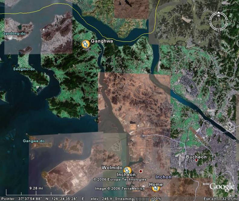
 Just a short update to regarding my bicycle trip up to Ganghwa. Ganghwa, marked on the map above, is an island along the northwest coast of Korea. They have a lot of historic sites, but I just visited some of the old forts and batteries along the east coast. There's some more stuff on the island I'd like to see, but I'll wait until the weather starts to warm and the days start to get longer.
 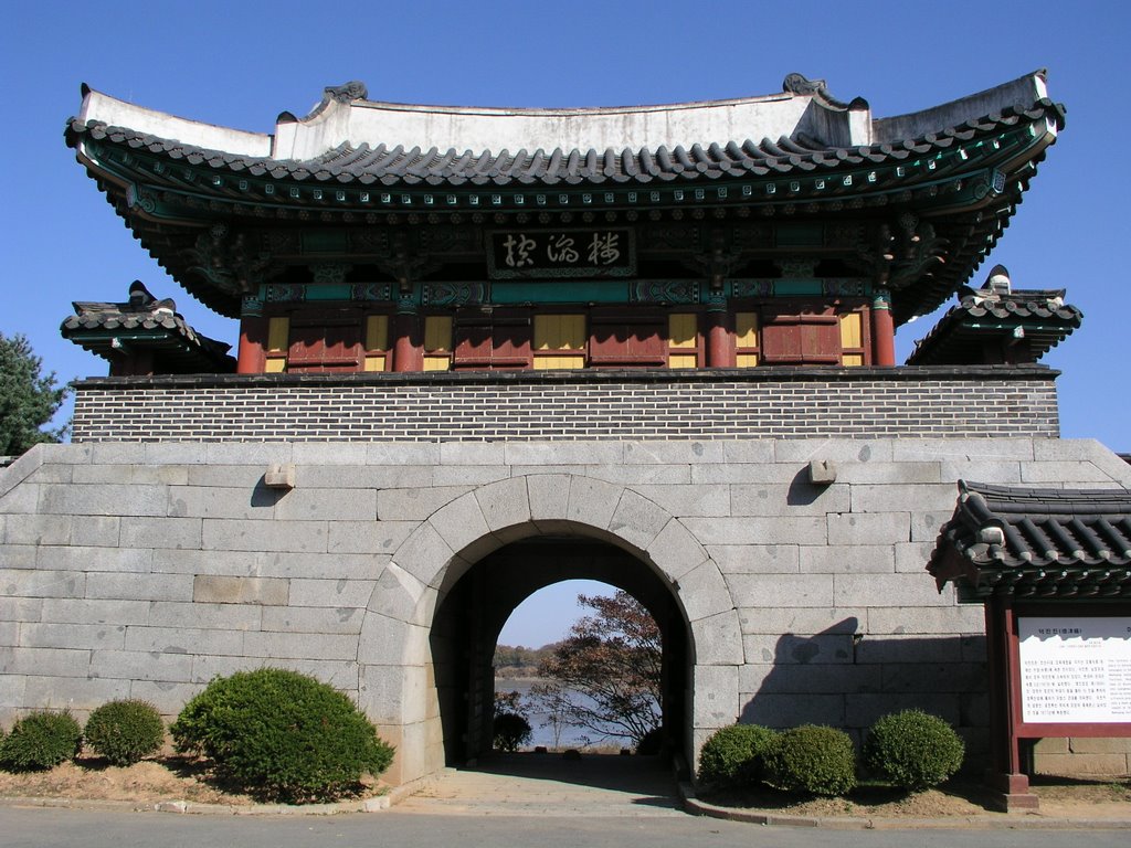 One of the most interesting aspects of the trip was the road along the coast from Incheon up to Ganghwa. As you may notice on the map, it is just down the coast from North Korea (the yellow line). So the ocean side of the road is lined with a couple of barbed wire topped, chain link fences, and guard towers all along the route.
That's about it for the excitement here. I'm heading back down to the fish market tomorrow after work to get some more pictures. So stayed tuned.

