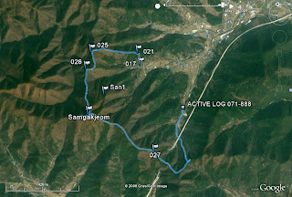
It was a nice today, so I decided to get some exercise and do some hiking in the mountains around my house. I'm mapping the trails so that I don't get too lost. Here is the route I took. My house is #17 on the map. 
Since my GPS records elevation, I thought I'd include that as well.
At #26 I discovered what appears to be a helicopter pad. Or maybe it's just a slab of concrete on top of a mountain. From the growth around it, it seems to have been abandoned some time ago.
Not far from the slab of concrete is a grave site. There are graves scattered all over the place around here, but most are much lower lying. Over Chuseok (the Korean Thanksgiving) families will usually visit the graves of their ancestors and have a small ceremony. I'm not sure if people still visit this one, but it is a reasonably vigorous hike up there. I even saw another grave site on the next mountain over. It would be at least a 2 or 3 hour hike from any village in the area.
My next finding was one of the electrical towers that carry power lines over the mountains. #27 on the map, for those keeping score at home. There's actually a dirt road that led up to this tower. The second structure on your left holds a cable that I presume was used to transport supplies to the next tower over, which isn't connected to the road.
Taking the dirt road, I heard some noise. I uncovered a group of workers assembling another tower. They were rather surprised to so me.
Working on the high steel.
The view from the tower. Most of the time the trees block the view, so it was good to get a glimpse of everything from up high.
The tower from further away.
Sunday, May 10, 2009
The neighborhood II
Subscribe to:
Post Comments (Atom)


No comments:
Post a Comment