This weekend, I stumbled upon a major discovery. A very nice bike path that extends north up to Incheon Grand Park. Which is a nice ending point to grab some overpriced food and people watch. The route also connects to my south/east route through Sorae, across the rice fields, to the Greenway (see a few posts down), and beyond. Meaning that there is an almost 30km long bike route that is almost entirely bike paths and back roads. If I have time before I head back home, I'll try to map the entire route out on Google Earth. But given my current schedule, it might have to wait until August or September.
In the meantime, some picture from my ride.
I found this horse stable in the fall. They actually have a small track for the horses to run around as well.
I was a bit surprised to find this cattle "ranch" in town.
I was even more surprised to find this deer "ranch". It seems they're being raised for their antlers, as several had had them cut off (see deer #27 in the photo). I don't know if it's some sort of Oriental Medicine thing, or what.
Sunday, June 24, 2007
Oh deer!
Thursday, June 21, 2007
The Big Fill In
This probably isn't of much interest to anyone not familiar with Incheon. But since I spent some time working on it, I figured I might as well post it. This is an image of Incheon with the boundaries of Incheon from 1950 overlayed onto it. The red overlay is actually a map of MacArthur's 1950 invasion. Everything outside of the red boundaries is reclaimed land. I knew there was a lot of reclaimed land, but I didn't know it was that much. 
Saturday, June 16, 2007
Muui-do
The latest island I visited is Muui-do. It can be reached by a short ferry ride from Jamjin-do, which is accessible by bridge at the southwest corner of the airport island. It's a small island, about 6km long and 2-3km wide. There are a couple of nice beaches that look like they'll get pretty crowded. Crowds were already beginning to develop, and the Korean beach season doesn't begin until July. There is an admission fee to the beaches though - W2,000, or about $2 - and each beach requires a separate fee. Here is a picture of one of the beaches.
The ride to the island is quite easy. From Incheon station it's a short hop to Wolmi-do. Then take the ferry to the airport island. From the ferry, it is then a 20km very flat and straight ride to the next ferry. Another short ferry ride and you're back to biking. The island itself is fairly hilly, but given the size of the island, it's not too bad. But access to both beaches requires a steep climb and descent. It's an easy day trip, even by bicycle.
Sunday, June 10, 2007
The DMZ
Sunday was a trip that I've wanted to take for some time now. That was to venture as close to the DMZ as I could. To the north of Incheon, the Han River forms the border between North and South Korea, and I was hoping to get a glimpse across it. So we loaded up our bikes onto the subway and headed to the end of the line, Gyeyang station. It's an impressive new station that serves as the transfer point between the Incheon line and the airport line. From there, we headed north through Gimpo, and then northwest towards Ganghwa. The traffic was pretty busy, so I guess a lot of people were headed there for the day.
There were a couple of roads that headed up to the Han, so we took the first one we reached. All was going smoothly until we reached a town a couple kilometers from the river. Just past the town, we hit a marine checkpoint that wouldn't let us past. So we asked them about going to another spot on our map, a little red dot that was labeled 애기봉전망대 (aegibongjeonmangdae, whatever that means), and they seemed to suggest that it would be okay. So we back tracked a little and began heading west. A few kilometers of that, and we espied a body of water. The Han, we were guessing. So we headed north, a little leery of being stopped again. But fortunately, we are able to bike right up to the fence running alongside the river. Since it completely obstructed the view, we looked for higher ground. Unfortunately, that higher ground was occupied by a bunker. But since it didn't appear that anyone was occupying the bunker, we decided to test our luck. And what do you know, the two of us managed to capture the bunker and assume a position over looking the Han. I guess they're not expecting an invasion to come from the south.
From our position on top of the bunker. This is the fence that is keeping the North Koreans at bay. That, and a mile of river to cross and a couple of 20-something Korean marines.
Still not satisfied with the view, and spurred on by the little red dot on my map, we decided to continue onward. So we headed back down the hill, along the fence, and towards the hill where the little red dot beckoned us. The road, which is more like a driveway than a road, headed back into the hills. Still not sure if we we're supposed to be there, we continued along, passing by bunkers, a small marine post, and more bunkers. To the right, there was a dirt road heading up the hill with the red dot. So we took that road, which soon turned to a dirt path. Off the bikes we went, as we continued by hiking. Soon, the path reached a cul-de-sac, surrounded by the hill. But we could hear vehicles nearby. We soon noticed cars and vans driving overhead in front of us, and then discovered steps leading upwards. We took the steps, and discovered a nice, two-lane paved road heading towards the sought after red dot. Along the road we hiked for about one kilometer, and then, much to our surprise, discovered the red dot. Aegibong.
It was almost a let down, as it was more of a tourist trap then a hidden discovery. The parking lot was filled with cars and buses. There was a store selling all kinds of things. Mainly junky souvenirs, but they did have some North Korean liquor. While a bottle of DPRK Cognac would certainly be a nice conversation piece, $40 seemed a bit excessive. There was a large crowd that was being greatly entertained by a man telling stories. We're not sure what about, but the crowd seemed to enjoy it. After wondering around the area for a while, we finally found the vantage point that we came for. High on the hill, looking directly into North Korean territory.
Koreans taking a peak at the North
The contrast between North and South is quite stark. While South Korea has reforested the hills, the North remains bleak and bare. There's a small village for the South Koreans to look at as well. Apparently, people even live there as well. How it is suppose to entice the South Koreans is beyond me. The buildings are even more unappealing than the South Korean apartment buildings. And there's no sign of cars, nor any type of super market or norae bang (singing room), which are both basic staples of any Korean village. If that's the window display, I'd hate to see what the inside of the store looks like.
A couple views of North Korea
After getting our fill of North Korea, we headed back down to our bikes. Knowing that there was a road to be had, we went back to the little drive, and soon found the main road. After traveling a short way down the road, we came across another marine checkpoint. They looked rather surprised to see us, especially since we hadn't passed through the checkpoint on the way up. After a brief consultation with another guard, we were saluted and waved through. I'm still not sure if we were supposed to be up there though. It looked like the Koreans passing through the checkpoint had to produce some papers and the guard had a stack of ID cards that he was holding on to. But hey, playing the clueless foreigner card pays off sometimes.
From there, is was just the simple matter of following the roads back to the subway station. The overall trip was around 62 km.
Saturday, June 9, 2007
The Greenway
Saturday was another trip out to Ansan for lunch. I've been searching for new routes along the way, and I've discovered a few nice diversions. One interesting aspect of Korea, is that there is very little sprawl. The suburbs around Seoul are growing quickly, and new housing is being built all over. But the housing is not spacious subdivisions that over run the farmland. Rather, they are neat and compact high-ride apartment complexes. So you can quickly go from the crowded city to fields of rice. Below are a couple of examples where city meets country.
So I've been taking advantage of this, and heading out into the rice fields. Now that the rice has been planted, the fields are a lovely green. There are access roads which criss cross the fields, and these make nice leisurely routes. Occasionally, I also discover some hidden gems. Like the path below. It cuts through a small wilderness zone that is amongst the mudflats around Sorae.
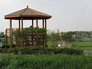
Another discovery was this walking and biking path. It's name is the "Green Way." That's not a translation, it's literally "Green Way," written in Hangeul. It's a nice 7.5 km route through the fields, with only one road crossing to deal with. The map shows how blocks of apartment buildings dot the land.
A nice big pagoda for people to hang out in
So that's the latest discovery to reveal. Oh, and I had some very good Vietnamese food in Ansan. Shrimp fried rice with beef and onions.
Sunday, June 3, 2007
Sorae, revisted
I've posted about Sorae before, and I'll do so again today. I finally timed the arrival of the boats correctly and remembered to bring my camera. So here are some pictures of the action.
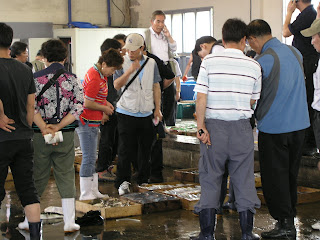
The most fascinating thing is how everything is in such close proximity. From the boats to the trading floor to the market or restaurant is a matter of feet. And while all the unloading and selling of fish is going on, the public is free to mill around, potentially falling off the dock, getting run over by a cart, or just being a general nuisance. It's definitely something you don't get to see in America.
The boats are crammed into the dock
The fish are offloaded and carted across an outgrowth of the market
Buyers check over the lot
The bidding begins
The lots are set aside and tagged


